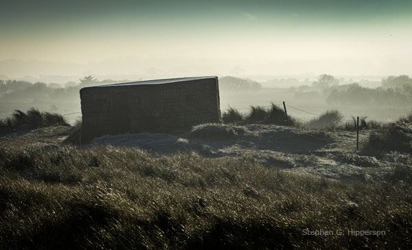
WWII Pillbox in the dunes at Horsey Gap, Norfolk.
—Stephen G. Hipperson—

WWII Pillbox in the dunes at Horsey Gap, Norfolk.
—Stephen G. Hipperson—

—Stephen G. Hipperson—

I snapped this bust in the Vatican Museum in Vatican City, primarily because of a likeness I saw to a well known TV presenter/anthropologist in the UK. Like a numpty, I didn’t record any details so I decided to do some online research, like you do. I found a picture of a sculpture by Ferdinand Pettrich, also in the Vatican Museum. If that subject and this one aren’t the same person then they must be sisters! Anyway, details on that work point to the sitter as being a lady from the Sauk-Fox tribe – or more properly the Sauk tribe of the Fox language group. I’m happy to be corrected on any of this, as the sad history of Native Americans doesn’t form part of any educational input I’ve had. I now know Black Hawk was a member of the Sauk tribe.
—Stephen G. Hipperson—

—Stephen G. Hipperson—

This 19th Century folly is near Masham, in North Yorkshire. William Danby, the local landowner paid some local unemployed labourers a shilling a day to construct it.
https://www.britainexpress.com/counties/yorkshire/properties/druids-temple.htm
—Stephen G. Hipperson

It’s not often I see something which I’ve never noticed before – these stylised representations of fish gave me cause to pause a while. I’m quite sure these are not particularly unusual, but it’s something I’ll keep a look out for in future. I quite like the simplicity.
–Stephen G. Hipperson—

I could have done with taking this 1/2 hour later, I would to have liked better lighting on the front. But time was against me – I was getting a bit of ‘hurry up’ from the rest of the family and I’ve found I can push it only so far! 😉
—Stephen G. Hipperson—

Also known as ‘The Stanton Tower’ and ‘Earl Grey Memorial Tower’.
The tower was erected following the passing of the Representation of the People Act in 1832 – which ‘threw a spanner in the works’ of representational democracy in Parliament.

—Stephen G. Hipperson—

—Stephen G. Hipperson—

I wasn’t sure about the contrails in this one, but I suppose they reinforce the diagonals of the winch structure.
A while since I put up a post – it’s a bit of a brain teaser trying to remember the way to do it!
—Stephen G. Hipperson—
